
Project Overview
Active quarry and aggregate operations require repeatable, defensible volume measurements to support production tracking, inventory reconciliation, and operational planning.
In this project, Aerial Insights LLC was engaged to deliver RTK-enabled aerial mapping and stockpile volumetrics designed to reduce uncertainty, limit manual survey exposure, and provide consistent results across future measurement cycles.
The Challenge
- Traditional stockpile measurement methods often involve:
- Manual ground surveys in active haul zones
- Inconsistent reference surfaces between measurement dates
- Difficulty comparing volumes across time with confidence
For quarry operators, consistency matters more than single-flight precision. Small alignment shifts between datasets can create false volume changes that impact reporting and decision-making.
Our Approach
To support reliable volumetric and change-detection workflows, we deployed a repeatable accuracy framework combining:
- RTK positioning during aerial data capture
- Permanent ground control point (GCP) targets installed on site
- GNSS-based validation using network correction services
This approach ensures datasets align consistently across flights, even when captured weeks or months apart.
GNSS validation is used to improve confidence in alignment and repeatability.
Deliverables are provided as aerial data products and are not represented as licensed land surveys.
Deliverables are provided as aerial data products and are not represented as licensed land surveys.
Data Capture & Processing
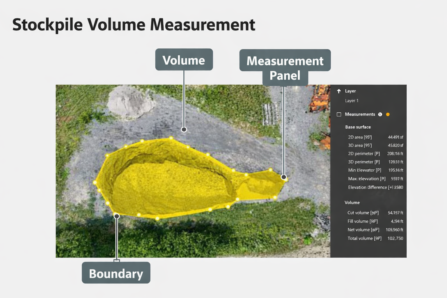
Using RTK-enabled drone workflows, we captured high-resolution imagery optimized for volumetric analysis and processed the data in DJI Terra to produce:
- Orthomosaics aligned to permanent control
- 3D surface models and point clouds
- Base-plane normalized volume calculations
- Cut / fill and net volume reporting
Both projection area vs fitted area metrics were evaluated to ensure boundary accuracy and surface integrity.
Typical Deliverables
For this quarry project, deliverables included:
- Stockpile volumes (cut, fill, and net volume)
- Quarry pit and face documentation
- Earthwork and grading progress surfaces
- Multi-date comparison visuals
- Client-ready reports with browser-based viewing options
- 3D mesh and point cloud datasets for internal review
These outputs are designed to integrate into operations, planning, and reporting workflows, not just visual reference.
Results & Value
By combining RTK capture with permanent ground control and GNSS validation, the client gained:
- Reliable, repeatable volume measurements
- Reduced need for manual survey exposure in active areas
- Improved confidence in month-to-month inventory changes
- Clear visual documentation to support production tracking
This workflow is especially valuable for active quarries, aggregate yards, and industrial sites where long-term consistency is critical.
Best Fit For
- Quarries & aggregate operations
- Materials yards and depots
- Industrial sites with recurring volume tracking needs
- Monthly or milestone-based reporting programs
From Pilot to Program
Most quarry clients begin with a pilot volume measurement and move into monthly or quarterly monitoring once workflow fit and reporting value are established.
Start with a pilot capture to evaluate accuracy, deliverables, and reporting clarity before scaling into a recurring program.
Request a Pilot Volume Measurement
or
Schedule a Site Review
GNSS + RTK validation is used to support aerial data alignment and improve confidence in multi-date measurements. Deliverables are provided as aerial data products and are not represented as licensed land surveys.
Typical Industrial Deliverables
- Stockpile volumes (cut / fill / net volume)
- Quarry face and site documentation
- Earthwork and grading progress tracking
- Multi-date comparison visuals
- Client-ready reports and browser-based viewing options
Request a pilot volume measurement or schedule a site review to evaluate accuracy and workflow fit.
Quarry & Stockpile Mapping
Quarry Stockpile Volumetrics with Repeatable Accuracy
RTK + Permanent GCP workflows designed for production tracking, reconciliation, and multi-date confidence.
Quarry Stockpile Volumetrics with Repeatable Accuracy
RTK + Permanent GCP workflows designed for production tracking, reconciliation, and multi-date confidence.
Stockpile Volumetrics
Volume calculations + reporting
$500 – $1,500
Volume calculations + reporting
$500 – $1,500
Large / Multi-Stockpile Sites
Change tracking + comparisons
$2,000 – $5,000+
Change tracking + comparisons
$2,000 – $5,000+
Thermal Inspections
Piping, stacks & asset scans
$1,500 – $4,000
Piping, stacks & asset scans
$1,500 – $4,000
Quarry Pit Mapping
Pit mapping + stockpile volumes
$1,000 – $3,000
Pit mapping + stockpile volumes
$1,000 – $3,000
Service Area: Toledo • Northwest Ohio • Southeast Michigan
Contact: 576-461-0301 | www.aerialinsightsllc.com